
I shared a photo of my grandmother Eveline Coates’ high school graduating class in Mystic, Iowa a few months ago. Along with the photo and her diploma, a couple of other mementos were saved. One is the program for the Junior-Senior Banquet in honor of the graduating Seniors. It was interesting to see how World War I seemed to be the overarching theme of the festivities. I decided to take a deeper look at what her life may have been like during the 1917-1918 school year.
Eveline’s Senior Year, Part 1
Eveline’s Senior Year: The Draft and a Carnival
Eveline’s Senior Year: A Look Around Town
Eveline’s Senior Year: Musical Notes
Eveline’s Senior Year: Smallpox
Eveline’s Senior Year: What are you Serving?
Eveline’s Senior Year: Root Beer on the 4th
Sepia Saturday provides bloggers with an opportunity to share their history through the medium of photographs. Historical photographs of any age or kind become the launchpad for explorations of family history, local history and social history in fact or fiction, poetry or prose, words or further images. If you want to play along, sign up to the link, try to visit as many of the other participants as possible, and have fun.
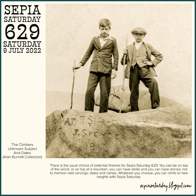
The prompt image this week highlights two boys atop a rock that has carvings of letters and dates. This was a nudge for me to dig into coal mines and miners and maps.
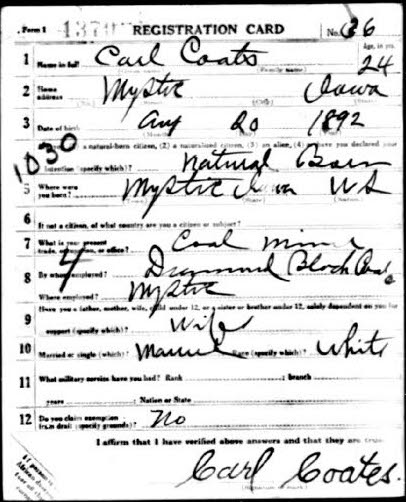
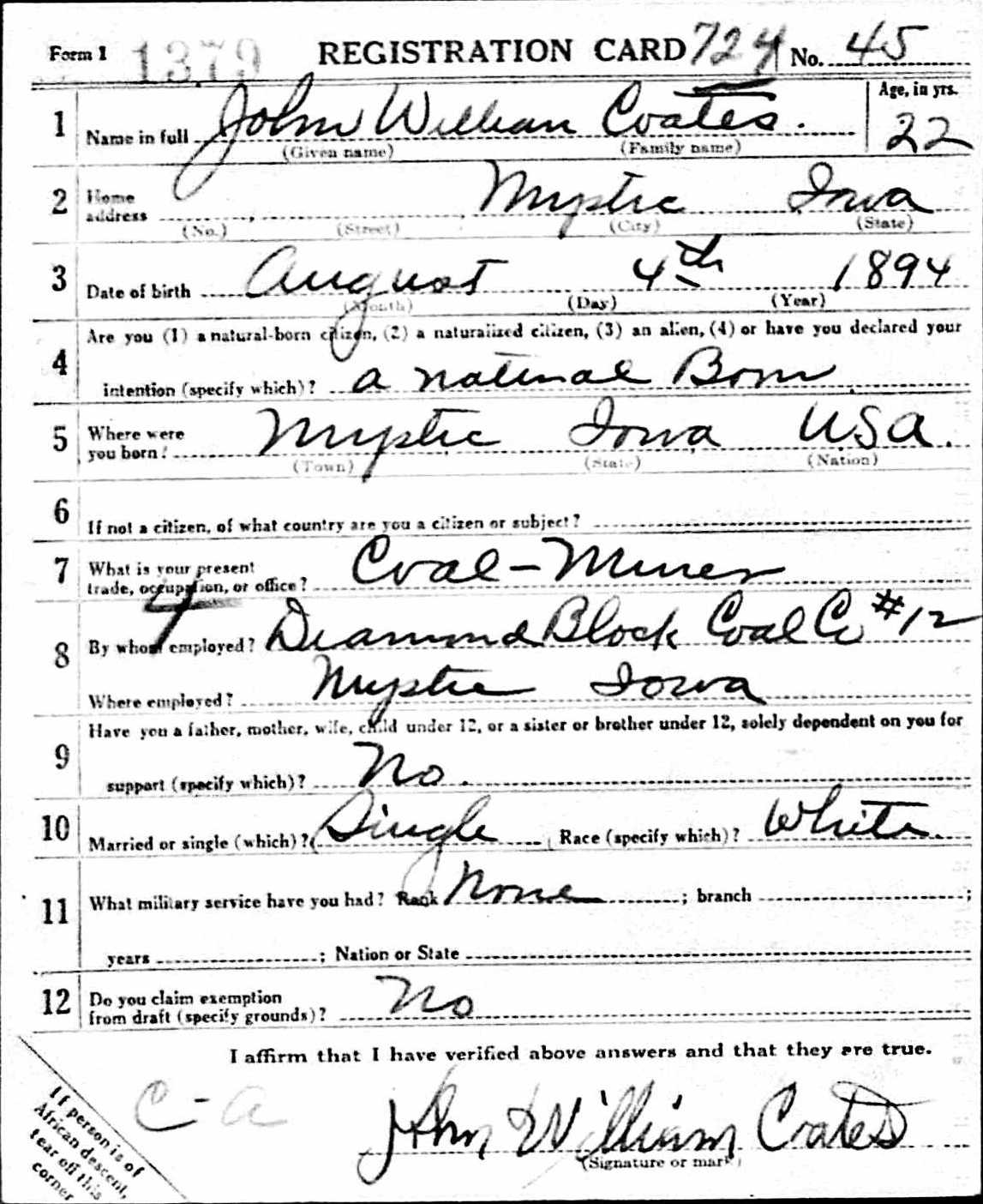
In an earlier post in this series, I included the 1917 draft registration cards for Eveline’s two older brothers, Carl and John. The brothers worked as coal miners for Diamond Block Coal Co. John’s form clearly indicates that he is employed at mine #12.
It has taken me a while to locate the mine and where it was situated in relation to Eveline’s home. I’m not the most efficient researcher, but I can be persistent. Now that I think I figured it out, it seems simple. Sigh.
Fortunately, I visited the Appanoose County Historical and Coal Mining Museum several years ago and purchased most of the available booklets. I could not have pieced much together without those resources. The first is an untitled booklet that must be copies of a larger book as the cover page is page 16. I’ll include an image of the cover because it also includes a legend for understanding the enclosed maps and shows the location of Mystic in the county.
My scan of a copy of a copy isn’t great, but the arrow points to the relevant designation for an underground coal mine.
The page below is opposite a map of the mines in Mystic and here I found the notation for Diamond Block Coal Co. No. 12.
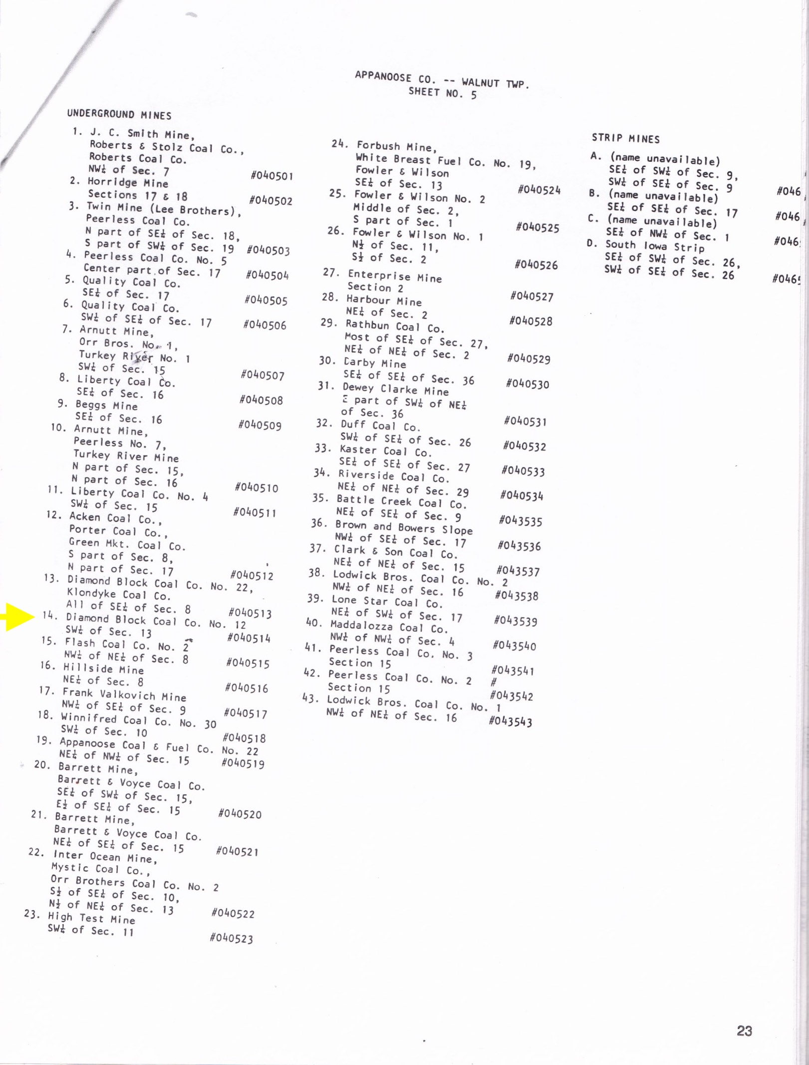
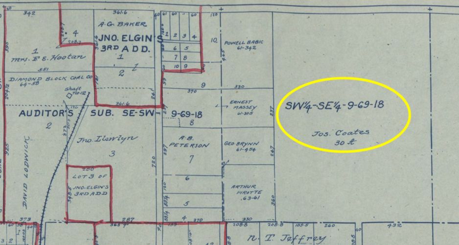
SW1/4 of Sec. 13 #040514
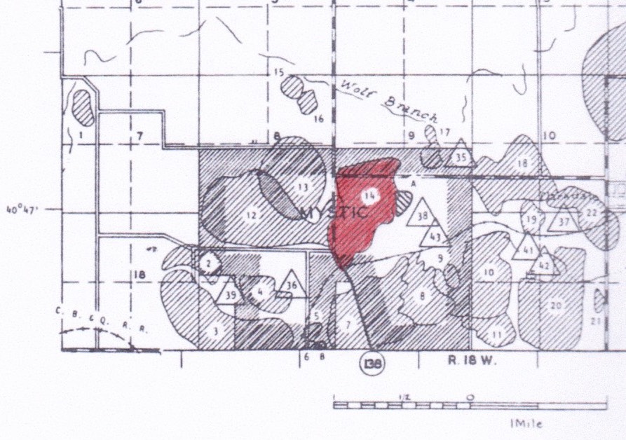
The town of Mystic is on the bottom portion of the map. Coal mines are located within the town limits and most, but not all, are underground mines. I have highlighted 14 on the map, the Diamond Block Coal Co. No. 12.
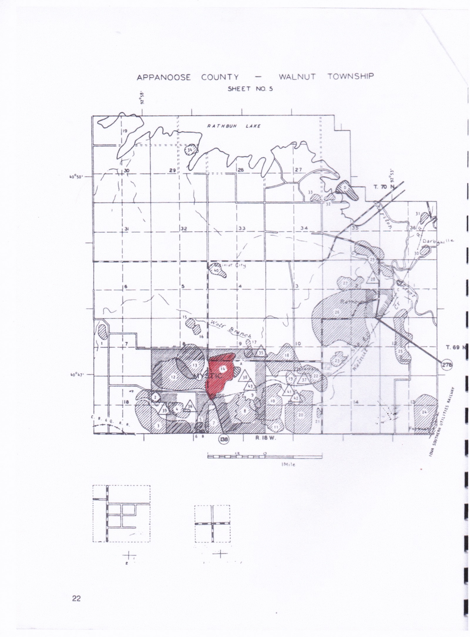
In the late teens of the 20th Century, Mystic had between 18 and 23 mines operating at once, with each mine having access to the railroad for the hauling of their coal. And at one time there were three switch engines that stayed in Mystic just to pull loads of coal, and they hauled 35 to 40 carloads a day.
History of Mystic, Iowa: 1887-1987, pg. 25.
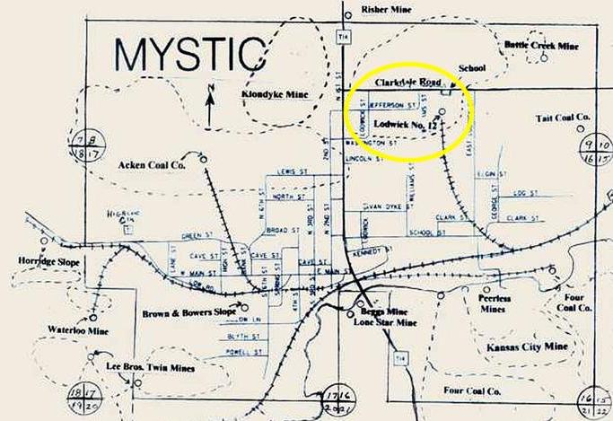
Another book I picked up includes this map (which I found somewhere on the internet for a better copy). But here the mine is identified as Lodwick No. 12.
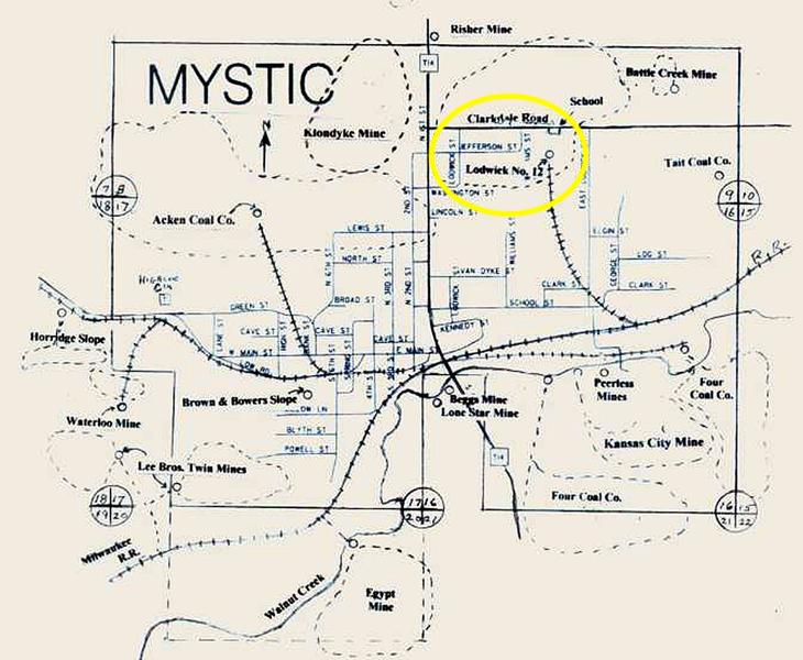
Mystic Block Coal Co. No. 12 – Lodwick Bros.
Heusinkveld, W. M. 2007, The history of Coal mining in appanoose county, iowa, p. 85.
Location: NE SE SW of Section 9, T-69N R-18W, Walnut Twp., northwest part of Mystic
Lodwick Bros. Coal Co, 1889-99, Diamond Block No. 12, 1905-14, Mystic Block No. 12, 1907-20
Slope & vertical, longwall and room & pillar, 123 acres, unknown depth
David Lodwick was General Manager with 400 employees producing 170.000 tons in 1916.
One source says the mine is located in Section 9 and the other in Section 13. This confused me, but when I place these two maps side by side they match pretty well, accounting for the difference in scale. Mine 3 on the left map is identified as Twin Mine (Lee Brothers) just as on the map on the right.
Everyone apparently knew the mine by its number, no matter who owned it. The Heusinkveld book states that it was the Diamond Block No. 12 only until 1914. It gives the years the name Mystic Mine was used as 1907-1920. At least that’s the way I read it. Maybe there is a typo in the dates? In any case, Carl and John reported that they worked at the Diamond Block mine when filling out their draft registration cards in 1917. Joseph Coates, their father, also worked in a coal mine. He didn’t have to register for the draft in 1917, so I don’t have that record for confirmation, but it is likely that they all worked in the same mine.

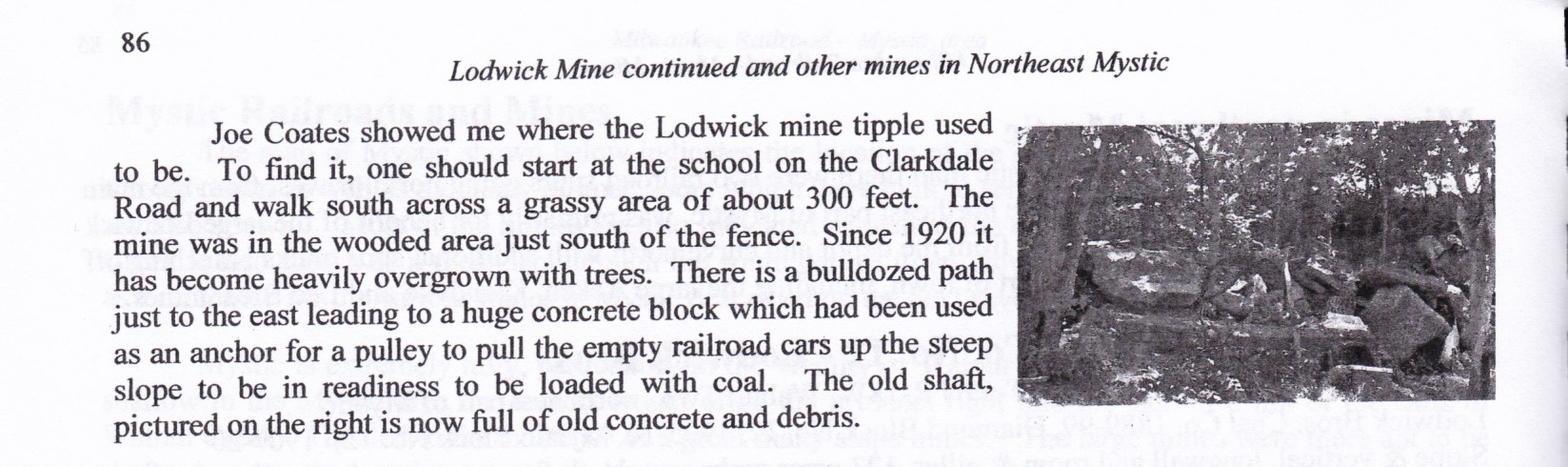
One of the best known mines in Mystic was the Lodwick Mine, pictured here. It was drilled in 1889 three years after the Milwaukee Railroad came through Mystic and two years after the town was platted. … The Lodwick Brothers, David and Llewyn, established their Lodwick Bros. Coal Co. in 1889. A third brother, Gwelyn S. Lodwick was an engineer and invented much of the equipment for the mines, such as the dirt dump car and possibly the mining machine.
Heusinkveld, W. M. 2007, The history of Coal mining in appanoose county, iowa, p. 85.
Often the local boys went to work in the mines after completing 8th grade, possibly looking just a bit older than the boy on the left in the prompt photo. It was my understanding that this was true for Carl and John. However, the 1910 Federal Census shows Carl working as a miner, but Johnnie, age 15, working as a delivery boy for a store.
The Atlas of Appanoose County, Iowa, 1915 contains the plat map for Mystic. I located Joseph Coates in the upper right corner. His plot of land is larger than I expected. I have not yet found any deeds or land transactions for more details. The map image file is too large to include here, so I’ll just include the relevant portion. There are a few street names on the map, but no streets adjacent to the Coates property are named.
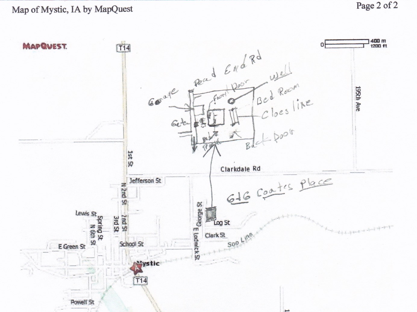
My mother and her siblings grew up in Mystic. Her brother Roy provided me with a sketch of how he remembers the location of the Coates home. He located the house between Clarkdale Rd. and Log St.
A look at these two maps side by side …
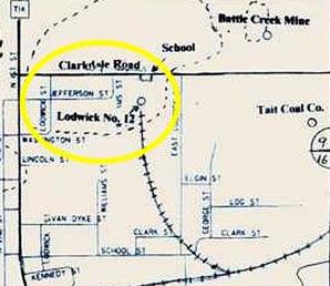
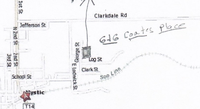
The map on the left shows the location of the #12 mine to the west of E. Lodwick St. – not far from the Coates home. I got out my ruler and looked at the scale on the map on the right and it came out to about 1200 feet, or less than 0.3 of a mile. The mine was within walking distance, although they could have taken their buggy.
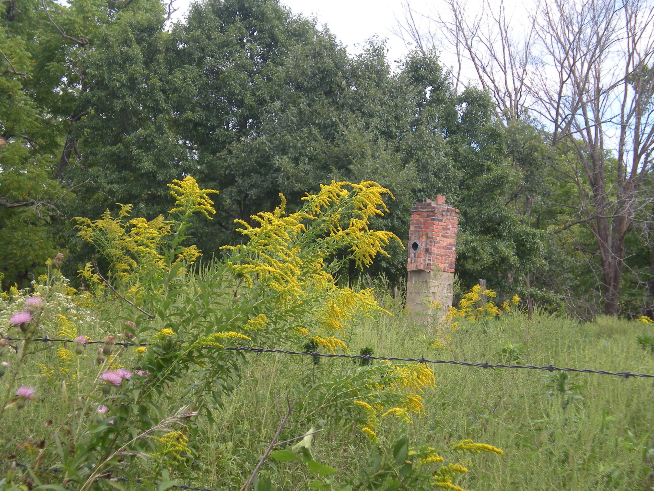
In 2016, I made a trip to Iowa and my Uncle Roy gave me a quick tour of Mystic. He located the property where his grandparents lived – and where his mother Eveline had grown up. All that remained was a chimney.
by Kathy Morales
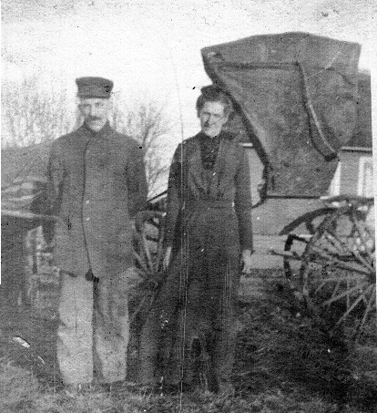
The Heusinkveld book also has this photo and mentions Joe Coates (Junior), the son of Eveline’s brother Joseph Robert Coates.
I’ve dug up a little more, but it is this end of this miner’s work day. Please visit other Sepia Saturday bloggers and see what summit they have topped. Sepia Saturday
Excellent sleuthing again! So glad you had those books with the maps of the mine…and its entrance does seem convenient to your ancestors.
When I bought those books I thought I was overdoing – a couple of them looked pretty boring. But now I’m really glad I did.
My husband’s ancestors were miners in West Yorkshire, England , and your detailed research has promoted me to find out more about where they lived and worked in what must have been a harsh life in all its aspects.
Eveline’s father and his family worked in the mines in Durham, England before he left for the US. I would like to learn more about them as well. If you find any good resources, I’d love to know!
Excellent research! Industrial history is always more interesting when seen from the perspective of the workers. Years ago when my son was about 7-8, the age of prime curiosity, we visited a coal mine museum in West Virginia and a lead mine living history center in County Durham, England. In both mines we got a brief experience of what conditions were like for the men and boys who once worked in these dark and dangerous places. Needless to say my son gave up any ambitions to become a miner!
Joseph Coates was from a coal mining family in Durham. I’ll put that history center on my bucket list.